Tectonic setting of the northernmost volcanic belt of the central cordillera, colombia
Published 2005-01-11
Keywords
- Radar,
- Landsat,
- Earthquakes,
- volcanoes,
- GPS
- tectonic,
- Central Cordillera ...More
How to Cite
Abstract
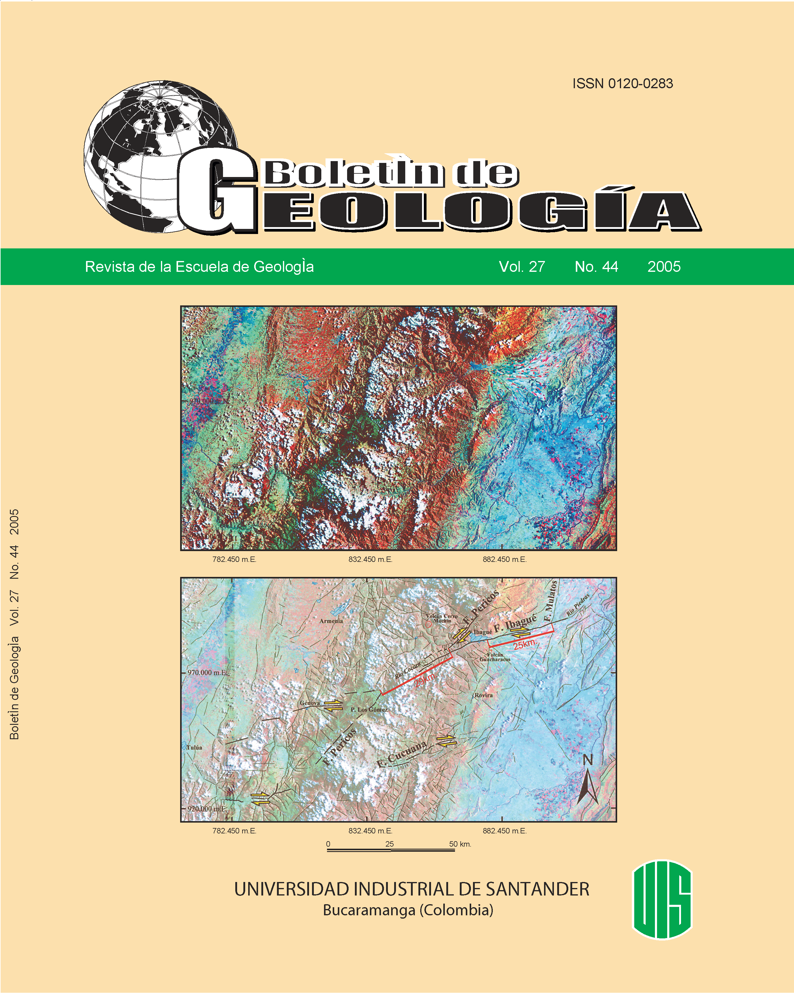
The northernmost Colombian recent volcanism is located in the central part of the Central Cordillera between the Romerales and Machín volcanoes. This volcanic belt is bounded by transversal fault systems, observed in an area of 10.000 km2. Radar and Landsat images interpretations, earthquakes locations, relative displacements of blocks, active faults studies and published geological maps were used to constrain this volcanism. Three major fracture orientations systems were recognized in the region. The fist system strikes N-S and is parallel to the Central Cordillera foothills. The second is oriented NW-SE and is related to the Rio Arma Fault and similar structures. The third with a SW-NE tendency is comparable with structures such as the Garrapatas and Ibagué faults. Faulting and recent volcanism relationship was identified, as well as their seismic activity. Additionally, the relative importance of the identified tectonic structures was established. Finally a micro-block is proposed for the region and their relative directions and magnitudes of displacement were determined using GPS methods. This analysis allow us to propose the Ibagué and Arma fault systems as tectonic boundaries of a crustal block that represents the subduction of a slab segment under the continental arch, generating the recent volcanism in this part of the Central Cordillera.
Key words: .
Downloads
References
Atehortúa F.; Gutiérrez G. (2003). Análisis estructuralde las rocas aflorantes en los alrededores de la FallaSilvia-Pijao al oeste de Manizales. Tesis pregado,Universidad de Caldas, CD-ROM. Manizales
Bohórquez, O. P., Gil-Cruz, F., Ospina, L. (2001). Sismodel Quindío del 25 de enero de 1999. Tensor de esfuerzospreliminar y estudio de réplicas. Revista HorizontesNaturales No. 4 Ene –Dic de 2001. Universidad deCaldas. Manizales.
Bohórquez, O. P., Patiño, J. (2001). Comportamientosísmico del sistema de Fallas de Silvia-Pijao en eldepartamento de Caldas. Rev. R.S.R.E.C., Manizales,Vol. 6, pp. 38-42
Bohórquez, O. P.; González, L.; Jaramillo, M. (2001).Estudio Neotectónico Multidisciplinario. Caso de Estudio:Falla Villa Maria Termales. VIII Congreso Colombianode Geología. CD ROM. Manizales
Caballero, H.; Zapata, G. (1983). Mapa Geológico de laplancha 224. Ingeominas. Bogotá
Calle, B.; González, H.; De La Peña, R.; Escorce, E.;Durango, J., (1980). Mapa Geológico de las planchas166 y 186. Ingeominas. Bogotá.
Ceballos, J.; Castañeda, A.; Roberson, K. (1994). Análisisgeodinámico de la actividad volcánica de Colombia.3ª.Conferencia Colombiana de Geología Ambiental,Armenia, Tomo I, pp. 93-119
Escobar, M. M. (2002). Segmentación de la Falla deRomeral con base en estudios existentes. Tesis dePregrado. Universidad Nacional de Colombia SeccionalMedellín, 240 p
Estrada, J. J., Viana, R. (1998). Mapa Geológico de laplancha 205. Ingeominas.Flórez, M. (1986). Geomorfología del área de Manizales- Chinchiná. Cordillera Central de Colombia. En: Análisisgeográfico IGAC. Bogotá, Vol. 9, 159 p.
Garzón, G. (2001). Catálogo de Fuentes Termales delParque Nacional Natural de los Nevados. Ingeominas.Informe Inédito
González, H. (1980). Geología de las planchas 167(Sonsón) y 187 (Salamina). En: Boletín Geológico.Ingeominas. Bogotá, Vol. 23, N° 1, pp. 1-174
Guzmán G., J., Franco, G., Ochoa, M. (1998). Proyectopara la mitigación y el riesgo sísmico de Pereira,Dosquebradas y Santa Rosa. Evaluación neotectónica.CARDER. Pereira, 144 p.Hall, M.; Wood, C. (1985). Volcano-tectonicsegmentation of the northern Andes: Geology, Vol. 13No.3, pp. 203-207.
Hincapie, J. O. (1994). Un modelo de convergencia deplacas para el noroccidente suramericano con base endatos sismológicos. Tesis pregado, Universidad NacionalMedellín, 103 p.