UPPER NEOGENE STRATIGRAPHY IN THE SOUTH OF TUMACO BASIN (COLOMBIAN PACIFIC): CASCAJAL FORMATION, LITHOSTRATIGRAPHIC REDEFINITION PROPOSAL
Published 2016-10-31
Keywords
- Colombian Pacific,
- fore arc,
- Tumaco Basin,
- stratigraphic code,
- volcanism
How to Cite
Copyright (c) 2016 Boletín de Geología

This work is licensed under a Creative Commons Attribution 4.0 International License.
Altmetrics
Abstract
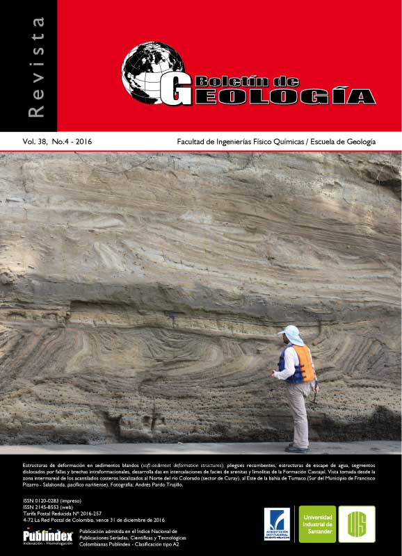
The stratigraphic knowledge of the sedimentary fill of the Tumaco onshore fore-arc basin is relatively poor. Previous works are based on the study of seismic lines and wells for hydrocarbon exploration with minor emphasis on the surface segments. We present a detailed study of the late Miocene - Pliocene rocks that outcrop in the southern Tumaco basin. New stratigraphicdata from the ANH-Tumaco 1-ST-S well represent the most complete and best preserved sections for this time interval. This information is integrated with new data from descriptions of ~200 m of stratigraphic sections visited in the coastal cliffs of the Tumaco bay and the Patia river. The detailed descriptions of these locations following parameters from stratigraphic codes allow us to propose the use of the term Cascajal Formation to refer to volcanoclastic rocks of Messinian – Zanclean age. This succession, with an estimated thickness of up to 405 m, is composed mainly of thick lenticular and undulated layers of sandstones and conglomerates, with an important volcanic input. Minor interbedded mudstones and muddy sandstones are present too. Locally, ichnofossils, bivalves, gastropods, foraminifera, echinoderms, crustaceans and well-preserved plant remains were preserved, interpreted as formed in a deltaic system influenced by volcanism.
Downloads
References
- ANH - Universidad de Caldas. 2011a. Estudio geológico integrado en la Cuenca Tumaco Onshore. Síntesis cartográfica, sísmica y análisis bioestratigráfico, petrográfico, geocronológico, termocronológico y
- geoquímico de testigos de perforación y muestras de superficie. Contrato No. 092 de 2009: Cartografía geológica a escala 1:100.000, cuenca Tumaco onshore. Manizales, Colombia, 215p.
- ANH - Universidad de Caldas. 2011b. Estudio integrado de los núcleos y registros obtenidos de los pozos someros (slim holes) perforados por la ANH, Contrato No. 093 de 2009.Manizales, Colombia, 215p.
- Arango, J.L., y Ponce, A. 1980. Mapa geológico generalizado del departamento de Nariño escala 1:400.000. Reimpresión 1996. República de Colombia. Ministerio de Minas y Energía. Instituto de
- Investigaciones Geológico-Mineras. Bogotá, Colombia, 47p.
- Aspden, J.A. 1984. The geology of the Western Cordillera and Pacific coastal plain in the departament of Valle del Cauca (Sheets 261, 278, 279, 280 and 299). Report No. 7. INGEOMINAS - Misión Británica. Cali, Colombia, 57p.
- Aspden, J.A., y Nivia, A. 1984. La geología de la plancha 278-Bahía de Buenaventura: escala 1:100.000, INGEOMINAS - Misión Británica (B.G.S). Cali, Colombia. Barbosa, A.A. 2012. Historias térmicas de la cuenca Tumaco y sector sur de la Cordillera Occidental:
- Implicaciones para la generación de hidrocarburos y evolución tectónica del noroccidente de Suramérica. Universidad de Caldas. Manizales, Colombia, 95p.
- Becerra, I., y Usma, V. 2008. Modelamiento geológicogeofísico a la altura de 3N desde el graben de Yaquina hasta el Cratón de la Guyana. Facultad de Ciencias Exactas y Naturales, Universidad de Caldas. Manizales, Colombia, 58p.
- Bedoya, E.L., Flores, J.A., y Pardo, A. 2013. Nanofósiles calcáreos y bioestratigrafía del Mioceno Tardío del SW de la cuenca Tumaco onshore (Pacífico colombiano). Boletín de Geología, 35: 55-66.
- Cediel, F., Restrepo, I., Marín-Cerón, M.I., Duque-Caro, H., Cuartas, C., Mora, C., Montenegro, G., García, E., Tovar, D., and Muñoz, G. 2010. Geology and Hydrocarbon Potential, Atrato and San Juan Basins, Chocó (Panamá) Arc, Colombia, Tumaco Basin (Pacific
- Realm).ANH. Medellín, 172p.
- Cohen, K.M., Finney, S.C., Gibbard, P.L., and Fan, J.X. 2013. The ICS International Chronostratigraphic Chart. Episodes, 36: 199-204.
- Correa, I., Hermelin, M., Martínez, J.I., Sierra, G., Toro, G.E., y Restrepo, J.D. 2008. Cuenca Tumaco (onshore y offshore), Cuenca San Juan y Cuenca Atrato. Inventario, interpretación y evaluación de la información geológica disponible, elaboración de los paquetes técnicos y promocionales ronda de áreas abiertas 2009. Convenio
- Universidad EAFIT-ANH. Medellín, Colombia, 113p.
- Deniaud, Y. 1998. Evolución tectono-sedimentaria de las cuencas costeras Neógenas del Ecuador. Convenio Petroproduccion / ORSTOM. Quito, Ecuador, 74p.
- Di Celma, C., Cantalamessa, G., Landini, W., and Ragaini, L. 2010. Stratigraphic evolution from shoreface to shelf-indenting channel depositional systems during transgression: Insights from the lower Pliocene Súa Member of the basal Upper Onzole Formation, Borbón
- Basin, northwest Ecuador. Sedimentary Geology, 223(1-2): 162-179.
- Earth Satellite Corporation. 1999. Geology of the Pacific Coast of Colombia. Rockville, Maryland, 36p.
- Echeverri, S., Cardona, A., Pardo A., Monsalve, G., Borrero, C., Valencia, V., Rosero S., and López, S. 2015.
- Regional provenance from southwestern Colombia fore-arc and intra-arc basins: implications for Middle to Late Miocene orogeny in the Northern Andes. Terra Nova, 27 (5): 356-363.
- Echeverri, S., Pardo, A., Hincapié, G., Cardona, A., Rosero, S., and López, S. 2012. Dating clastic injection events in Tumaco basin: integration of geochronology and stratigraphic proxies. VIII South American symposium on Isotope Geology - SSAGI. Medellín,
- Colombia, 93p.
- Echeverri, S., Borrero, C., Moreno, M., Pardo, A., y Castillo, H. 2011. Nomenclatura estratigráfica para la sucesión neógena expuesta en la bahía de Tumaco (cuenca Tumaco costa adentro, SW de Colombia) - Redefinición y formalización. XIV Congreso Latinoamericano de Geología y XIII Congreso Colombiano de Geología. Medellín, Colombia.
- Escovar, R., Gómez, L.A., y Ramírez, J.R. 1992. Interpretación de la Sísmica Tumaco 90 y evaluación preliminar del área: Bogotá. Empresa Colombiana de Petróleos (ECOPETROL). Bogotá, Colombia, 74p.
- Evans, C.D.R., and Whittaker, J.E. 1982. The geology of the western part of the Borbón Basin, North-west Ecuador. Geological Society, 10 (1):191 - 198.
- Galindo, V., y Torres, M.E. 1995. Mapa Geológico Compilado de la Cuenca de Tumaco. Ecopetrol –Geología Sistematizada Ltda.
- González, H. 2008. Investigación Integral del Anden Pacífico Colombiano. Convenio administrativo INGEOMINAS-IGAC. Tomo 1. Bogotá, Colombia, pp. 83-86.
- Haq, B.U., Hardenbol, J., and Vail, P.R. 1987. Chronology of fluctuating sea levels since the Triassic (250 million years ago to present). Science, 235: 1156-1167.
- INGEOMINAS-IGAC. 2005. Mapa geológico a escala 1:100.000 de las planchas: 361 BIS Tomo, 383 Tumaco, 384 La Chorrera, 407 Cabo Manglares y 408 Barbacoas.
- ISSC. 1994. International Subcommission on Stratigraphic Classification of IUGS, International Commission on Stratigraphy, International Stratigraphic Guide (2a edition, Amos Salvador, ed.). International Union of Geological Sciences y Boulder, Colorado, Geological Society of America. Trondheim, Noruega, 214p.
- Jaramillo, C.A., Rueda, M., and Torres, V. 2011. A palynological zonation for the Cenozoic of the Llanos and Llanos Foothills of Colombia. Palynology, 35 (1): 46-84.
- López, E. 2009. Evolution tectono-stratigraphique du double bassin avant - arc de la marge convergente Sud Colombienne – Nord Equatorienne pendant le Cénozoïque. GeoAzur. Nice, France, 349p.
- Lorente, M.A. 1986. Palynology and Palynofacies of the Upper Tertiary in Venezuela. Dissertationes botanicæ. Berlin, 222p.
- MacEachern, J.A., Bann, K.L., Pemberton, S.G., and Gingras, M.K. 2007. The Ichnofacies paradigm: Highresolution paleoenvironmental interpretation of the rock record. In: MacEachern, J.A., Bann, K.L., Gingras, M.K., and Pemberton, S.G. (Eds.). Applied Ichnology.
- Society for Sedimentary Geology Short Course Notes, 52: 27-64.
- MacEachern, J.A., and Bann, K.L. 2008. The role of ichnology in refining shallow marine facies models. In: Hampson, G., Steel, R., Burgess, P., Dalrymple, (Eds.). Recent Advances in Models of Siliciclastic Shallow-Marine Stratigraphy. SEPM Special Publication, 90: 73–116.
- Marcaillou, B., and Collot, J.Y. 2008. Chronostratigraphy and tectonic deformation of the north Ecuadorian-south Colombian offshore Manglares forearc basin. Marine Geology, 255: 30 - 44.
- Martínez, J.O., and López, E. 2010. High-resolution seismic stratigraphy of the late Neogene of the central sectorof the Colombian Pacific continental shelf: A seismic expression of an activecontinental margin. Journal of South American Earth Sciences, 31: 28-44.
- Martini, E. 1971. Standard Tertiary and Quaternary calcareous nannoplankton zonation. In: Farinacci, A. (Ed.). Proceedings of the II Planktonic Conference (1970). Roma, 2: 739-785.
- Montoya, D. 2002. Mapa geológico a escala 1:100.000 de las planchas: 240 Pichimá, 259 Malaguita y 260 Aguas Claras.
- Murcia, H.F., Borrero, C., Pardo, A., y Castillo, H. 2011. Depósitos volcaniclásticos en la cuenca de antearco de Tumaco: Evidencia de actividad volcánica en la Cordillera Occidental de Colombia. XIV Congreso Latinoamericano de Geología, Medellín, Colombia, pp. 245-246.
- NASC. 2005. North American Stratigraphic Code. North American Commission on stratigraphy nomenclature. AAPG Bulletin, 89 (11): 1547-1591.
- Nivia, A., Pérez, C., y Sepúlveda, J. 2003. Geomorfología y Geología de la Plancha 383 Tumaco. INGEOMINAS. Cali, Colombia, 37p.
- Okada, H., and Bukry, D. 1980. Supplementary modification and introduction of code numbers to the low-latitude coccolith biostratigraphic zonation (Bukry, 1973; 1975). Marine Micropaleontology. 5: 321-325.
- Oppenheim, V. 1949. Geología de la costa sur del pacífico de Colombia. Instituto Geofísico de los Andes Colombianos, 1: 1 -23.
- Patiño, J.C., Camargo, G., Caicedo, J.C., Gómez, H., Ariza, S., Suárez, F., Valencia, L.Y., Contreras, K., y Niz, L.D. 2008. Geología de superficie y geoquímica de rocas y crudos de la subcuenca del San Juan (Chocó). Informe final Servigecol Ltda. Bogotá, Colombia, 131p.
- Patiño, J.C., Gómez, H., Grajales, J.A., Dallos, C.C., Yepes, A.M., y Navarrete, L.A. 2011. Levantamiento de una sección geológica a escala 1.100.000 en el afluente principal del río Patía. Contrato Universidad de Caldas – Servigecol Ltda. Número 063 de 2010.
- Pemberton, S.G., MacEachern, J.A., and Ranger, M.J. 1992. Ichnology and event stratigraphy: the use of trace fossils in recognizing tempestites. In: Pemberton, S.G. (Ed.), Application of Ichnology to Petroleum Exploration. A Core Workshop. SEPM Core Workshop Notes, 17: 85-117.
- Pemberton, S.G., MacEachern, J.A., Dashtgard, S.E., Bann, K.L., Gingras, M.K., and Zonneveld, J.-P. 2012.
- Shorefaces. In: Knaust, D., Bromley, R.G. (Eds.). Trace fossils as indicators of sedimentary environments. Elsevier, Amsterdam, 64: 563–604.
- Pinilla-Ocampo, A., Ríos-Blandón, P.A., Rodríguez- Ramos, B.P., Sánchez-Aguilar, J.J., Pulgarín-Alzate, B., Borrero-Peña, C.A., y Roa-Vargas, H.J. 2008. El Neógeno volcánico en el Altiplano Nariñense, suroccidente colombiano. Geología Colombiana, 33: 69-78.
- Rosero, S., Silva, J.C., Ducea, M., Pardo, A., Echeverri, S., and López, S. 2012. Strontium isotope chronostratigraphy from Neogene successions in the Tumaco basin, SW Colombia. VIII South American
- symposium on Isotope Geology - SSAGI. Medellín, Colombia, 157p.
- Salazar, G. 2002. Mapa geológico a escala 1:100.000 de las planchas: 202 Pilizá y 221 Pizarro. INGEOMINAS. Schlumberger. 2011. Pozo ANH-Tumaco 1-ST-P, evaluación de registros, Int. 750 – 4930 ft, escala 1:200. Cuenca Tumaco, Nariño – Colombia.
- Seilacher, A. 1964. Biogenic sedimentary structures. In: Approaches to Paleoecology (Imbrie, J., and Newell, N. ed.), Chichester, UK, John Wiley y Sons, pp. 296-316.
- Spikings, R.A., and Crowhurst, P.V. 2004. (U-Th) / The thermochronometric constraints on the late Miocene- Pliocene tectonic development of northern Cordillera Real and the Interandean Depression, Ecuador. Journal of South American Earth Sciences, 17: 239-251.
- Suárez-Rodríguez, M. 1990. Estudio geológico regional e interpretación sísmica estratigráfica en la provincia sedimentaria de la costa pacífica. Empresa colombiana de petróleos GEX-ICP, 117p.
- Suárez-Rodríguez, M. 2007. Geological framework of the Pacific coast sedimentary basins. Geología Colombiana, 32: 47-62.
- T.G.T. Gamas. 2011. Registro gráfico compuesto pozo ANH-Tumaco 1-ST-P, Int. 40-11.738 ft, escala 1:500 Cuenca Tumaco, Nariño – Colombia. Van der Hammen. 1958. Estratigrafía del Terciario
- y Maastrichtiano continental y tectogénesis de los Andes Colombianos. Investigaciones de Estratigrafía y Palinología, INGEOMINAS. Informe interno 1279. Boletín de Geología, 6(1-3): 53-54.
- Wetzel A. 2008. Recent bioturbation in the deep South China Sea: a uniformitarian ichnologic approach. Palaios, 23: 601-615.